I had to drop the wife's car in for a service today so I planned on walking home from the Garage then returning once the service was complete.
I planned a couple of routes and drove to Lookers near Star City, leaving the car a little after 8. I was told that the car would be done by 12 which gave me time to walk home, grab a coffee and then I'd be out again.
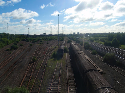
First port of call, was Washwood Heath Sidings. Built for the Midland Railway from 1877, this marshalling yard was enlarged over the years.
After a short, cul-de-sac excursion up Wolseley Drive, for another view of the former LDV, I was at the site of the former boozer, The Bromford. After standing derelict for some years, the building has been demolished to make way for some shops with flats above.
From The Bromford, I made my way up Bromford Lane, past the Police Station, to The Fox and Goose. I backtracked, slightly, to Brockhurst Lane. This led to Bromford Road and thence to Collingbourne Road.
On reaching Chipperfield Road, I turned down Kempson Road (named after the racecourse). After a few twist and turns I was at The Clock garage where I planned on catching the bus home for my coffee break.
Looking at the display on the bus shelter, I was informed that the next 94 would arrive in 14 minutes. In my head I calculated when I'd get home and when I'd have to depart and decided to keep on walking, joining up with my original route at the aforementioned Fox and Goose.
From the Fox and Goose, opposite which used to be the Beaufort Cinema, until it's closure in 1978, I continued along Washwood Heath Road.
On the approach to the shops at Washwood Heath, there is a newly erected 20 MPH sign. The road in front of the shops is a bit of a free for all, with cars parked willy-nilly, on the road, the pavement and even the zebra crossing. Instead of sorting out the traffic the council have slapped on a speed limit.
The shops themselves are a mixture from around the world with England, Pakistan, India, Turkey, Poland and recently Romania represented.
I finally left the B4114 on Aston Church Road passing a number of scrap metal dealers before arriving at the best known, Taroni's.
There is a road leading off Aston Church Road which doesn't appear to have a name. Google Maps has no name for it, neither does the AtoZ. Locally, Taroni has adopted it and named it - you guessed - Henry Taroni Avenue. There's even a sign.
It was around this point, that the garage phoned to tell me that the car wouldn't be ready until 12:30. I recalculated my route to include a bit of Birmingham's famous 'more canals than venice' waterways.
At the end of the A47, Heartlands Parkway, I crossed Saltley Viaduct going over, the River Rea, the Birmingham to Derby railway and the Grand Union Canal before reaching one of Brum's least attractive streets (no names, no pack drill).
Fortunately, this was short lived and I was soon on the much more attractive canal.
Back at Aston Church Road, I left this canal and proceeded to the Birmingham and Fazeley canal in Aston. From here I went under Spaghetti Junction and back on to the Grand Union, passing Star City on my left.
This time, on arrival at Aston Church Road, I made my way, once again, to Heartlands Parkway for a short walk, past the site of two huge gasometers, now demolished, to pick up the car from Lookers.
In total, I walked 17 miles covering a lot of previously un-walked Birmingham roads.


