I intend to walk every street in Birmingham. This will include every road (excluding Motorways and similar), canal towpath, public footpath and bridleway.

23 May 2016

Home Again, Home Again

Another walk home from work (Digbeth) starting on Garrison Street, passing the Birmingham City Mission building on Langdon Street with it's really useful four-sided clock tower, each of which displays a different, wrong, time !


Taking a side street off Landor Street (Clarel Avenue) brought me to this huge pile of junk !


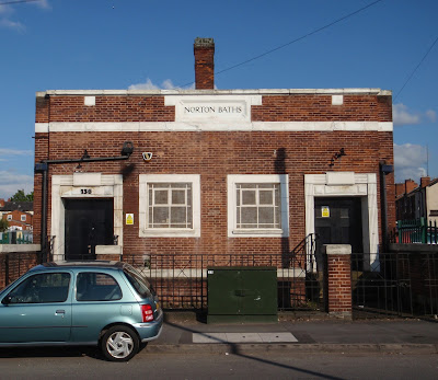
Proceeding along Adderley Road, I passed Norton Baths - or what remains of it. Opened in 1924, the swimming pool was built to the unusual length of 100 feet which made it a bit inconvenient for competitive swimming.

During the winter months the pool was covered over and used as a dance hall - luckily before the punk era and all that pogo-ing !!!

The baths have been closed for a number of years.


From Saltley Gate, I took the Washwood Heath Road as far as Ward End Park, where I turned left onto Drews Lane, passing the derelict site of LDV.

Formely, part of the British Leyland empire, Leyland Daf Vehicles was formed in 1993. The huge factory complex on Drews Lane made vans until 2009 when the company folded.

The last model of van produced in Birmingham, the Maxus, is still being built - in China.


The site is due to be re-developed as a business park providing around 3,000 jobs. There is some disagreement with the site owner, Alsom, who want the site as a maintenance depot for the HS2 (if it is ever built!)

From a former site of horsepower to another; although one with a lot fewer horses.

Where the Bromford estate sits today, was the site of the Bromford Bridge Racecourse. Opened in 1894, the course was 11 furlongs long.


The final meeting was held in 1965, when Lester Piggott rode a double. The last horse to cross the finishing line was named Plantation Inn.

The land was acquired by the Birmingham Corporation which built a housing estate there. There are a few reminders of past racing links with roads named Newmarket, Haydock and Thirsk. The abandoned Racecourse Pub still stands (just) on Bromford Drive.


At the end of Bromford Drive are the abandoned streets of, probably, an area of the Firs estate. The streets are still there, overgrown in places, but the houses which once stood have long gone.




19 May 2016

Walking Home from Work

As I may have mentioned in an earlier blog, I started a new job on Monday and having tools and other stuff to take into work and get sorted, I have had to use the car.

Today was the first day that I was able to go car-less and enjoy a walk home.

I cadged a lift to work this morning with my good lady wife and after a hard day's graft (stop sniggering at the back) I left work and headed straight for the canal heading towards Saltley.


After less than a mile, I left the canal at Landor Street which soon became Arden Road.


Just past what was once The Arden Stores, I deviated off to walk a small cup-de-sac called Lancelot Close, comprising of around a dozen houses. One of the residents watched as I walked to the end of the road, turn around and walk back. 
"I know what you're doing!" he said.
"I doubt it", thought I.
"You're doing your steps", he guessed.
"Not quite", and I explained what I was really doing.
He was quite impressed and thought it was a good idea - makes a change from the usual "Why?"


After a few more, residential, streets I was on the busy Alum Rock Road. A short walk along this cosmopolitan highway bought me to the amusingly named 'Curry Up!" takeaway.

Forking off from the main road, Cotterills Lane took me to the A4040, Bromford Lane. 


I left the streets here and followed the Cole Valley Cycle and Walkway for a mile or so to Packington Lane where I rejoined the road system to make my way though a bit of Shard End before crossing the Solihull border at Bradford Road.


Another mile or so, in Solihull, and I was home.

Another 8 miles walked with 6.8 of them in Birmingham.


14 May 2016

Shard End Shortie

Needed to get for some fresh air so took a short drive to nearby Shard End for a chance to walk a few more Brummie streets.

I chose a distinctive piece from the map...


I parked at the recently redeveloped Shard End shops and started my walk.

Lots of houses built from the 1940's up to a couple of years ago. 

Two features struck me, the first being the very wide Shardway from Packington Avenue,


and the other being All Saints Church, whose tower could be seen from any of today's streets.


Shard End Crescent has a rich musical history with ELO's Jeff Lynn and Duran Duran's Roger Taylor both growing up there.

13 May 2016

Highgate

After getting off the bus in the city centre, I filled in a few gaps from Monday including the little known, Dingley's Passage which, at present, ends at a building site some twenty metres after it's start.


Then it was a short stroll along New Meeting Street back to Dale End.


I made my way towards Sherlock Street, passing the site of the old Silver Blades (currently a building site) and the Wholesale Markets.


Once on Pershore Road and just before Belgrave Middleway, I turned left onto St. Luke's Road picking off all the little cul-de-sacs before finally reaching the middleway. I crossed the middleway at the lights, in sight of the mosque before starting a criss-crossing of the streets between here and Calthorpe Park.


Nothing too exciting but did come across a house, intriguingly called Little Rohtas. All that I can find out about Rohtas is that it was a fortified city in the Pakistan Punjab. Considering the cultural mix in this area that could well ring true.


From Little Rohtas, I made my way to Moseley in time to meet the wife from work.

Geeky Map Stuff

So far, every walk that I've done, I've tracked with my Garmin Forerunner 230 GPS watch. This is automatically saved to Endomondo on completion.

The resultant track (.GPX) is imported into Google My Maps where, although very messy, serves as a guide to where I've been.

On a fresh layer, I will trace the route and end up with a nice tidy line depicting my travels. I can then delete the original .GPX

The new track is moved to my main layer holding all my walks for the month.

I have another layer with a .KML file of the Birmingham Boundary.

I discovered today, that if I export the May 2016 layer as a .KLM into Garmin Base Camp, I can get a total of the distance walked.

Sorry if this is all a bit geeky but when I was planning this endeavour, this is the stuff I wanted to know - so it may be useful to someone.

12 May 2016

Sparkhill

Today's Trace
After a morning's sleep, after a night's work, I took a couple of buses and ended up in Sparkhill.

Sparkhill, was named after Spark Brook, a little stream which originally ran from Moseley into the River Cole at what is now The Ackers Trust. Spark Hill was a hill near the brook.

It all sounds like some country idyll and it was until around 1850 when, as a result of the industrial revolution, the area was developed for housing.

From the 1860's, many different developers were building in Sparkhill which accounts for the varied architecture of the area, although to be honest, most of it is fairly uninspiring terraced housing.

The streets were built in a fairly uniform pattern of straight streets which minimised the amount of zig-zagging needed to walk them all.

Shortly after starting, I was walking up one of many cul-de-sacs, when a slab-laying man stopped to say "Hello." This was probably the polite way of saying, "What the hell are you doing here?" We got chatting and I explained my mission to walk every street in Birmingham. Probably humouring me, he wished me luck and after a handshake, I resumed my walking.

Today's route looks a bit like a ladder with the Stratford Road and Stoney Lane being the stales. Along one of the 'rungs', I spied this interesting establishment...


On another 'rung', I noticed this car parked, oblivious to the request painted above the garage.


Across the road, adding the word 'please' has made absolutely no difference!


About 4 miles into the stroll, after passing this colourful display on the busy Stratford Road, I came to St. John's Church. During the war (to be read as Uncle Albert, in Only Fools and Horses, would), the nearby BSA factory was bombed. There is a memorial to those killed in the church.


Towards the end of today's journey, I noticed this forlorn shop on Stoney Lane. Once it must have been one of those places that specialised in all those bits and pieces that you didn't know the name of but nobody else stocked.


After completing the ladder, a short walk towards Moseley, allowed me to meet my other half from work.


Sheldon

No - Not THAT Sheldon !

Today, en-route to my last day at my current job, I stopped off in the Birmingham district of Sheldon.

Sheldon is on the eastern border of Brum, next to Solihull and Birmingham Airport. Today's area is mainly housing with a small shopping centre at The Radleys.

After parking the car, I started the, what is becoming familiar, zig-zagging of the streets. With this sort of street layout, some sections just have to be walked more than once.

A mile into the sortie I was walking up the short Wakeman Grove. Isn't it amazing that the council named a road after that Prog Rock God that is Rick Wakeman?


A little further on and the road narrowed to a path which leads across Sheldon Country Park, past the end of runway 1-5, to Marston Green. I turned around and continued along Elmstead Avenue passing an obviously hand made 'No Parking" sign.


Turning left onto Chaffcombe Road, I was greeted by a very orange house. Quite trendy for your traditional semi.


Chaffcombe Road turned into Rosecroft Road then ended at Church Road - the church in this case being St. Giles. This grade II listed building was mostly built in the 14th century and restored in 1867.

Just past St. Giles, Ragley Drive leads to Sheldon Country Park, a popular free attraction and one of the few places in Birmingham where you can see sheep !


As well as the usual farm animals, there is a small herd of Jersey cows.

Back on Church Road, I returned the way I had come but continued up the hill to what is commonly known as The Radleys Shops clustered around the roundabout.


After negotiating the pelican crossings, it was back to zigging and zagging to end up back at the car.


Another small area coloured in and 5 miles worth of shoe leather used, as I stated earlier, a lot of the route has to be re-walked.


10 May 2016

Shard End

Gateway to Birmingham
On nights and was fast asleep until around 12 when the phone rang.

"Hello", I said, groggily.
"Hello, Our records indicate that you were involved in an acci..." I hung up

After half an hour, trying to drift back to the land of Nod, I gave up, got dressed and grabbed a bite to eat.

I decided to go for a walk and in doing so I might as well colour in a new bit of Birmingham. The area I chose was near to home - just a mile away.


An alleyway led from the B4114, Chester Road, crossing the Solihull / Birmingham boundary and depositing me in Shard End.

There was persistent precipitation but as I always say, "There's no such thing as bad weather - just bad clothes". Decked out in Goretex I was protected from the elements as I weaved my way around Shard End.

A Lot of Allotments

In a section of new houses I spotted this particularly dangerous wall topped with broken glass. I haven't seen anything like this for many a year - isn't this illegal?
Dodgy Wall
After a few miles, I walked past the Kitsland Road shops, comprising of a Spar, Trevor the Barber and not much else. Many years ago, when I was living in nearby Kingshurst, there used to be an excellent off-licence here serving all manner of fine ales.

Short Back and Sides
I made a short excursion to Packington Road and the Mother of God and Guardian Angels church before doing a 180 to walk the bits that I'd missed.


On Silver Birch Road, I walked as far as the Solihull boundary before about turning, staying in Birmingham.

Welcome
Around Home Way, I was surprised to find two, eight foot tall, stone griffins. Apparently, there are 4 more in the area. Rumour has it that the Tsar of Russia gave the griffins to the city of Birmingham, back in the 1890's. They used to perch on the roof of the 'old' Lewis's building before that was demolished for the 'new' store in 1923.

The griffins were moved to flank the entrance to the Yorkswood Scout Camp and when that closed in 1972 to make way for the current housing estate, the griffins stayed put.

Guardian Griffins

Griffin
Further into my travels, I spied this house owned by someone who would rather be living in a much older dwelling.

Urban Country-style

Not all of the houses are as well looked after...

Needs a bit of TLC
Towards the end of my excursion to Shard End, I passed a ship. Well, technically, a training ship - TS Stirling set on the banks of Shard End Lake.

Ship Ahoy
By the time I got home, I had clocked up 10 miles. 2 miles can be deducted for getting to and from the boundary but that still leaves a walk of 8 miles to cover such a small area of housing estate.

9 May 2016

I've Started

There's no time like the present.

I decided to get an A-Z of Birmingham so that I've got a hard copy of where I've been.

I caught the bus into the city centre and started my GPS watch to track where I'd walked.

I started here, on the junction of Corporation Street and The Priory Queensway.

I made a, not-entirely-direct route to Waterstones from where I purchased a shiny new map book.

Whilst in the city centre, I decided to walk a few more streets and to get the ball rolling.

My route, according to my Garmin GPS watch, looks like this...


Looks like I was drunk ! All those tall buildings play havoc with the GPS signal. Using the above as a guide, I redrew the route in My Google Maps and this is the result...


The big picture showing how much of Birmingham that I have walked looks like this...


It's that little red squiggle in the middle. It looks very insignificant but you've got to start somewhere. Hopefully, it will fill up soon enough.

Here are a few shots taken on my initial walk...

Corporation Street, ready for the trams.

Pointless Cycle Lane

This chap's on the fiddle

The soon to be demolished, Pavilions

Sandwich Bar, Union Passage

Is it really Needless?

Great Western Arcade

The Minories

Priory Circus

Tony Hancock - Priory Circus